NOTE: Gray indicates insufficient data or a suppressed estimate.
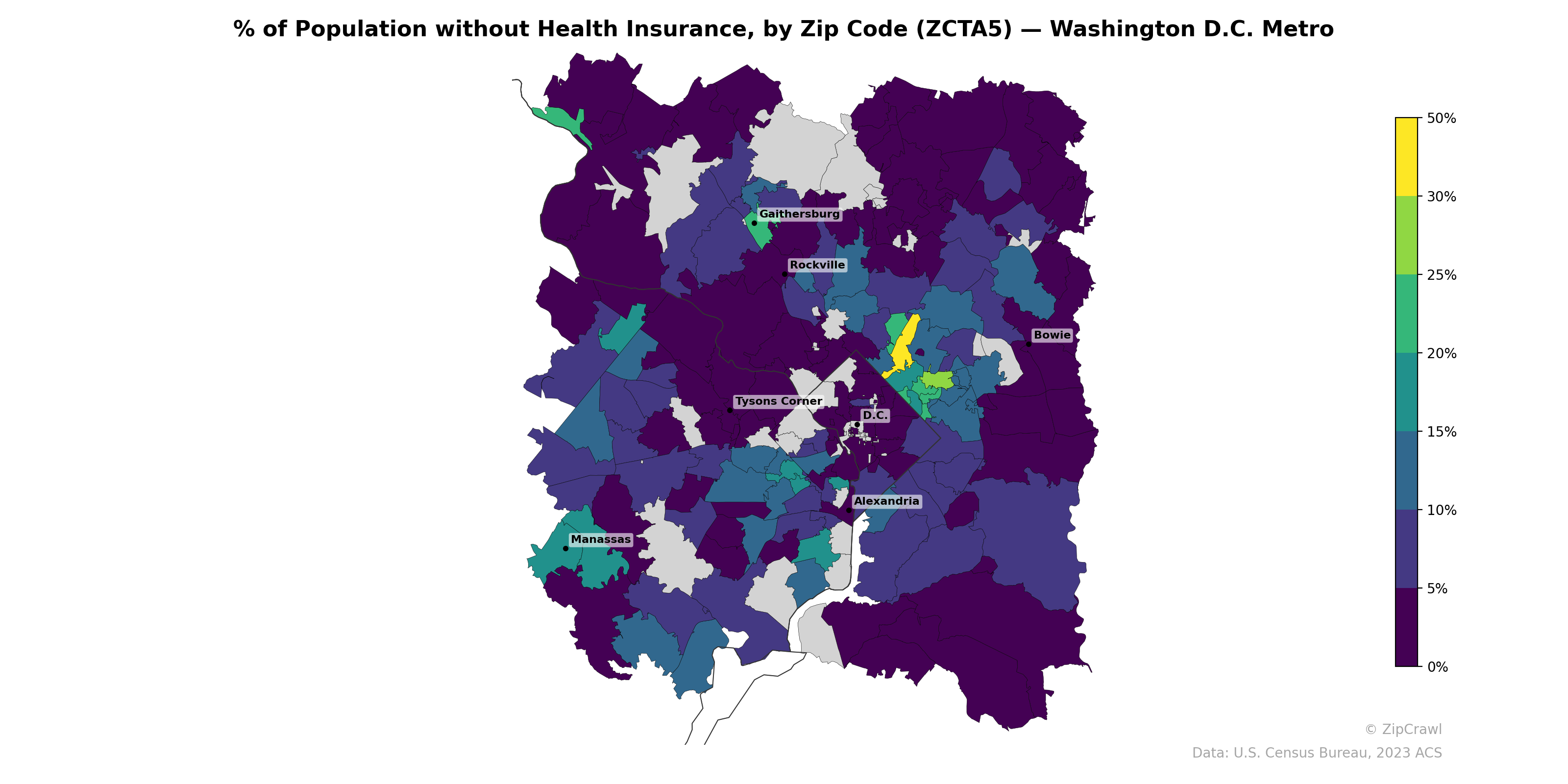
Uninsured rates in the Washington D.C. metro area exhibit stark geographic disparities, with the highest concentrations (30–50%) clustered in a narrow band of zip codes just north and northeast of downtown D.C., likely corresponding to immigrant-heavy communities, while surrounding affluent suburbs in Fairfax County, western Montgomery County, and the Bowie area consistently fall below 5%. A secondary cluster of elevated uninsured rates (10–20%) appears in the outer Virginia suburbs near Manassas and along the I-66 corridor, contrasting sharply with the very low rates in nearby Tysons Corner and Rockville-area zip codes. The gray areas with missing data around Tysons Corner and parts of northern Montgomery County may reflect zip codes dominated by commercial or institutional land use with minimal residential population.
Data: U.S. Census Bureau, 2023 ACS
Explore
- Married Couple (% of all Households) by Zip Code (ZCTA5) — New York Metro
- Married Couple (% of all Households) by Zip Code (ZCTA5) — Washington D.C. Metro
- Housing Owner-Occupied % of Units, by Zip Code (ZCTA5) — Washington D.C. Metro
- Housing Owner-Occupied Median Value ($), by Zip Code (ZCTA5) — Washington D.C. Metro
- Bachelor's Degree or Higher (% of Over 25) by Zip Code (ZCTA5) — Washington D.C. Metro
- % of Households with Broadband Internet, by Zip Code (ZCTA5) — Washington D.C. Metro
- Housing Vacancy Rate by Zip Code (ZCTA5) — Washington D.C. Metro
- Household Average Size by Zip Code (ZCTA5) — Washington D.C. Metro
- Housing % of Units Built Since 2010, by Zip Code (ZCTA5) — Washington D.C. Metro
- Housing Median Monthly Rent ($), by Zip Code (ZCTA5) — Washington D.C. Metro
- Population Non-Hispanic Asian % by Zip Code (ZCTA5) — Nebraska
- Population Non-Hispanic White % by County
- Population Non-Hispanic Asian % by Zip Code (ZCTA5) — New York Metro
- Housing Median Monthly Rent ($), by Zip Code (ZCTA5) — New York Metro
- Housing Owner-Occupied Median Value ($), by Zip Code (ZCTA5) — New York Metro
- % of Households with Broadband Internet, by Zip Code (ZCTA5) — New York Metro
- Housing % of Units Built Since 2010, by Zip Code (ZCTA5) — New York Metro
- Housing Vacancy Rate by Zip Code (ZCTA5) — New York Metro
- Household Average Size by Zip Code (ZCTA5) — New York Metro
- Housing Vacancy Rate by Zip Code (ZCTA5) — North Carolina
- Household Average Size by Zip Code (ZCTA5) — North Carolina
- Population Non-Hispanic Asian % by Zip Code (ZCTA5) — North Carolina
- Bachelor's Degree or Higher (% of Over 25) by Zip Code (ZCTA5) — North Carolina
- Housing Owner-Occupied % of Units, by Zip Code (ZCTA5) — North Carolina
- Population Non-Hispanic American Indian % by Zip Code (ZCTA5) — North Carolina
- % of Households with Broadband Internet, by Zip Code (ZCTA5) — North Carolina
- Housing Median Monthly Rent ($), by Zip Code (ZCTA5) — North Carolina
- Housing % of Units Built Since 2010, by Zip Code (ZCTA5) — North Carolina
- Married Couple (% of all Households) by Zip Code (ZCTA5) — North Carolina
- High School Graduate (% of Over 25) by Zip Code (ZCTA5) — North Carolina
- % of Population without Health Insurance, by Zip Code (ZCTA5) — Washington D.C.
- % of Population without Health Insurance, by Zip Code (ZCTA5) — Washington
- % of Population without Health Insurance, by Zip Code (ZCTA5) — Houston Metro
- % of Population without Health Insurance, by Zip Code (ZCTA5) — Boston Metro
- % of Population without Health Insurance, by Zip Code (ZCTA5) — Detroit Metro
- % of Population without Health Insurance, by Zip Code (ZCTA5) — Denver Metro
- % of Population without Health Insurance, by Zip Code (ZCTA5) — Dallas Metro
- % of Population without Health Insurance, by Zip Code (ZCTA5) — Miami Metro
- % of Population without Health Insurance, by Zip Code (ZCTA5) — Tampa Metro
- % of Population without Health Insurance, by Zip Code (ZCTA5) — Chicago Metro